Spatial Network Analysis for Multimodal Urban Transport Systems (SNAMUTS)
This project explores the implications on public transport network performance and land use-transport integration of a range of proposed tram service and infrastructure improvements within and affecting the City of Port Phillip. These improvements are currently under consideration by local and state government agencies. Their appraisal is intended to assist the City of Port Phillip in effective advocacy and Public Transport Victoria in prioritising actions.
Using the Spatial Network Analysis for Multimodal Urban Transport Systems (SNAMUTS) tool co-developed at RMIT University and Curtin University, public transport accessibility in metropolitan Melbourne and the City of Port Phillip is examined at the current level (February 2015) and in three future scenarios. These future scenarios assess the impact of proposed improvements to public transport infrastructure and services and projected urban growth, in particular the accessibility needs of the Fishermans Bend Urban Renewal Area.
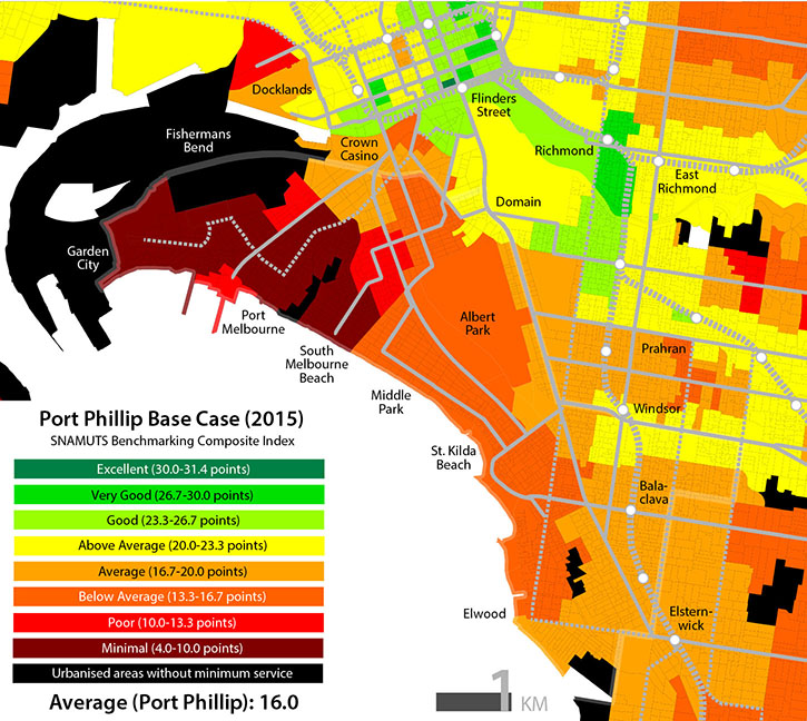
City of Port Phillip: SNAMUTS composite public transport accessibility map
Key People
Project Researchers
- Dr Jan Scheurer, Honorary Associate
- Kristen Bell, PhD Candidate
- Sevilla Furness-Holland, Research Assistant
Related Content
Research Programs
News & Blog


Acknowledgement of Country
RMIT University acknowledges the people of the Woi wurrung and Boon wurrung language groups of the eastern Kulin Nation on whose unceded lands we conduct the business of the University. RMIT University respectfully acknowledges their Ancestors and Elders, past and present. RMIT also acknowledges the Traditional Custodians and their Ancestors of the lands and waters across Australia where we conduct our business.
RMIT Centre for Urban Research
124 La Trobe St,
Building 8, Level 10
Melbourne City campus
Phone: +61 3 9925 2272
ABN 49 781 030 034
CRICOS provider number: 00122A
RTO Code: 3046
Open Universities Australia