This panel discussion is part of the 17th Venice Architecture Biennale 2021 Italian Virtual Pavilion Series, chaired by Lauren Rickards.
Moments of “water out of place” are accumulating and the place of water on the planet is being remade as oceans become more dominant. Coastal cities are already being impacted, with messy de-urbanization at land edges now accompanying and accelerating messy urbanization at inland city edges.
This panel discussion will explore:
- What principles and visions should guide efforts in new modes of aqueous urbanism?
- What is needed to adapt in positive ways?
- Which professional practices can “live with” seawater and which ones need to be abandoned or created anew?
Building resilient coastal communities: learning from Small Island Developing States | Alessandro Melis
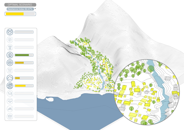
The GCRF project focuses on two island nations of the Caribbean – Dominica and Grenada – different for geographical location and morphology, but both subject to great risk from severe weather events and other natural disasters such as flooding, hurricanes, volcanic eruptions and earthquakes. This project combines expertise in disaster risk reduction and architecture, to increase the resilience of coastal communities. It integrates novel risk analysis and socio-cultural-economic features of communities in Small Island Developing States to produce good-practice guidelines for safer design, planning and management. The project also includes the use of Kassandra, an integrated decision support systems (IDSS). The IDSS has been used to define a series of key guidelines for the improvement of resilience of coastal communities to extreme climatic events caused by climate change. The guidelines bring together two different perspectives: a deterministic data-based analysis and a situated ecology assessment that includes human perspective. This method has allowed for the development of a more in-depth, comprehensive, and holistic understanding of the capacity of a system to be resilient and adaptable. The study saw the application of Kassandra on fifteen sites in the two islands analysing the current resilience of buildings, infrastructure, environment, air, and heritage. The recommendations, developed by Kassandra via iterative scenarios, include considerations about the five key factors that resulted to be the most influential ones in mitigating the risks and improving the overall resilience index:
- The geographical and topographical location of settlements
- The form of individual buildings
- The configuration and arrangement of clusters of buildings
- Construction techniques and materials
- The capacity of inhabitants to be self-sufficient for longer periods of time
In addition to applying Kassandra to the sites on both islands, a prototype building design was developed that considers the results of the Kassandra study and proposes an ideal resilient building capable of withstanding and adapting to most natural disasters.
Research team: Oren Lieberman (PI), Richard Teeuw (PI), Carmen Solana (PI), Alessandro Melis (PI), Guido Robazza (PI), Jessica Roberts (PI), Mark Cannata (Kassandra), Antonio Stornello (Kassandra).
Learn more about the GCRF project and the Kassandra project.
Alessandro Melis is an architect and the curator of the Italian National Pavilion at the 17th Venice Biennale. He is also a professor of architecture and the inaugural endowed chair of the New York Institute of Technology. is an Endowed Chair, New York Institute of Technology, New York.
Unthinking Coastlines | Lindsay Bremner
Some of the things that I have learned from studying the monsoon in south Asia are, firstly, that adapting to aqueous urban futures will require thinking in gradients rather than lines, thinking with rather than trying to control watersheds, wetlands and coastal ecologies, and rethinking the words and instruments we use to understand and represent these dynamic systems.
Coastal zones have long been thought and represented by the planning and cartographic practices of lines and datums – think of words like coastline, one-hundred-year flood line, sea level, even sea level rise. This imaginary enables the building of infrastructures like seawalls, coastal defences, canals and ports that produce land and sea as separate, mutually opposing domains – land as solid and fixed, sea as liquid and dynamic. This move is reflected too in the separation of cartographic practice into two separate disciplines – topography (land) and bathymetry (sea). At the same time, the binary between land and sea leaves out the air, a critical element in the dynamics that produce coastal zones in the first place and with which they are intimately entangled.
From this, follow a number of questions pertinent to aqueous urban futures.
Is the way land and ocean meet really a line? Or is it a liminal, fluctuating tidal zone, ecologically, culturally and socially charged with meaning, desire and mutualism, as well as risk and danger? Can the sciences of the line be countered by the ecologies of the gradient, in which land, sea and air are categories, cultures, imaginaries and ways of life that exist in a state of ongoing negotiation and flux? If we un-think the lines and categories that have delineated coastlines and fixed their meanings, can tides, flux, flow and other boundary-breaking phenomena forge new understandings of coastal ontologies, epistemologies and practices and ways of working with them? Can design-led interventions begin by “unthinking” the line? Can design and planning for coastlines be rethought according to the logics of gradients, of fluidity, flow, uncertainty and flux?
Lindsay Bremner is a research architect and educator at the University of Westminster in London where she is Director of Research in the School of Architecture and Cities. She recently (2016-2021) held European Research Council grant no. 679873 for Monsoon Assemblages, a project exploring three Bay of Bengal cities – Chennai, Dhaka and Yangon, as monsoonal assemblages being disrupted and transformed by globalization and climate change. She holds a B.Arch from the University of Cape Town and an M.Arch and DSc.Arch from the University of the Witwatersrand, Johannesburg.
Explore her work at Monsoonal Multiplicities Exhibition and Monsoon Assemblages.
Super Tight / Hyper Loose | John Doyle
The future of cities in the age of climate change and sea level rise presents a paradox for urban design.
As one of the major contributors to global greenhouse gas emissions, it is critical that cities are planned and adapted to be compact and consolidated.
At the same time, with over 570 cities around the world likely to be affected by sea level rise, cities will need to respond to a changing and uneven landscape, which frequently resists models of urban centrality.
Straddling these contradictions, future cities will need to be both supertight (densely settled within a small footprint) but also hyperloose (decentralised, dispersed and with minimal infrastructure).
The rapidly urbanising regions of Asia present a number of examples that could provide insights into a future hyperdense/loosefit urban model. Towards this the following are a series of preliminary observations and provocations that have emerged through our work over the last five years.
Future urban density must become performance based. It is not enough to consolidate cities, to shrink or stack existing models. The lived experience of cities in the region suggests a series of existing strategies that allow for the adaptation of life to changing conditions and the capacity to use existing cities to a level that far exceeds their planned intentions.
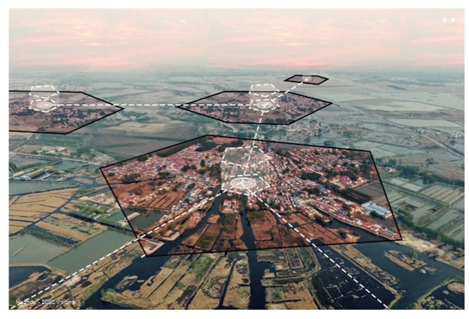
Future cities will not stand alone but be understood as a network. The Chinese mega-cities of the Pearl River and Yangtze River deltas provide examples of rapidly growing, self-contained cities that have morphed into one another form multi-nodal systems. While these clustered cities challenge the existing tools of governance and planning, they present a model that allows for high levels of dispersed density within a single urban system.
A new urban–rural compact must be formed. For example, the entire island of Java is more densely settled than any of Australia’s cities. If cities are defined by the colocation of people, Java should be considered as a single urban (rural) environment. Expanding the understanding of what constitutes a city to the macro scale, presents opportunities to develop a post-metropolitan model of distributed and decentralised (total) urbanism.
Future cities will be where we make and grow things. The highest density cities are often the most dependent on imported food, energy, goods, waste, etc. (e.g., Hong Kong). A compact city is no longer compact if it requires a vast global hinterland to support it. Folding production into the centre of cities densifies that production spaces of cities and allows cities greater independence (and therefore resilience) in global supply chains.
John Doyle is the Program Manager and Head of the Master of Architecture program at RMIT. He is a practising architect and a director of COMMON, a Melbourne based architecture and urban design practice.
Building resilience through design | Yazid Ninsalam
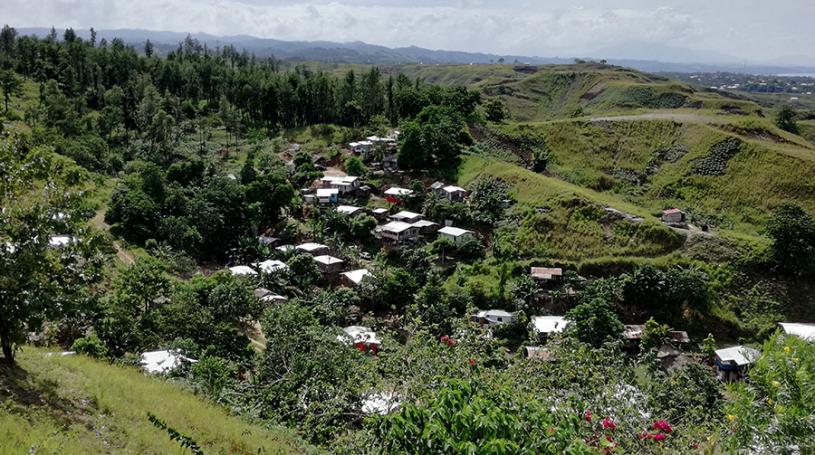
Our urban future lies in balancing the relationships of human settlements and community infrastructure with water and sanitation, floods, solid waste management. I will reflect on work undertaken as part of the Climate Resilient Honiara project at RMIT University, which studies settlements in Honiara, the capital of Solomon Islands. We focused on the settlements located within the valley of Vara Creek, which are characterised by steeply graded slopes and a flood-exposed valley floor. These settlements have been classified by the government as Informal Settlement Zones. They are defined by limited road access and services, with rubbish being frequently deposited into the creek, and many community members dependent on footpaths for access to schools, clinics, the bus network, and commercial areas of Honiara.
Communities are exposed to flash flooding and other secondary hazards associated with heavy and prolonged rainfall events, such as landslides. As a result of these conditions, residents are impacted by vector-borne and skin diseases resulting from stagnant water. These environmental conditions make up the primary climate-related vulnerabilities for these communities. What modes of enquiry can we undertake through the lens of design, to address:
- Site-specific topographical modifications to enhance community amenities
- Resilience-building actions that resonate with community-members
- Climate hazard awareness of communities and local impacts of climate change
- Housing relocation from high hazard risk zones
Learn more about Oceanic Cities here.
Yazid Ninsalam is a lecturer in the RMIT landscape architecture program and designer at McGregor Coxall. He has worked with a range of stakeholders to mitigate the impacts of landscape transformation, and competing pressures of urban development and climate variability, on the management of natural and built assets. He previously worked as a landscape architect for the National Parks Board and served as Council Member in the Singapore Institute of Landscape Architects. He was conferred a doctoral degree in architecture by the National University of Singapore and was a researcher at the Future Cities Laboratory, established by ETH Zurich and Singapore National Research Foundation.
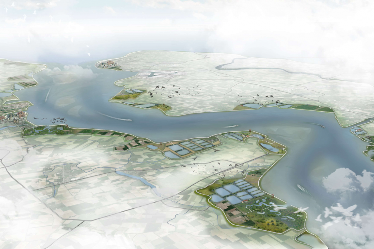
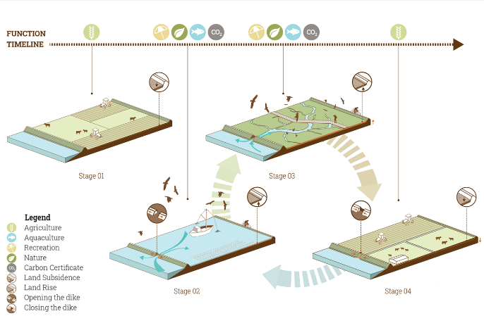
Anne Loes Nillesen
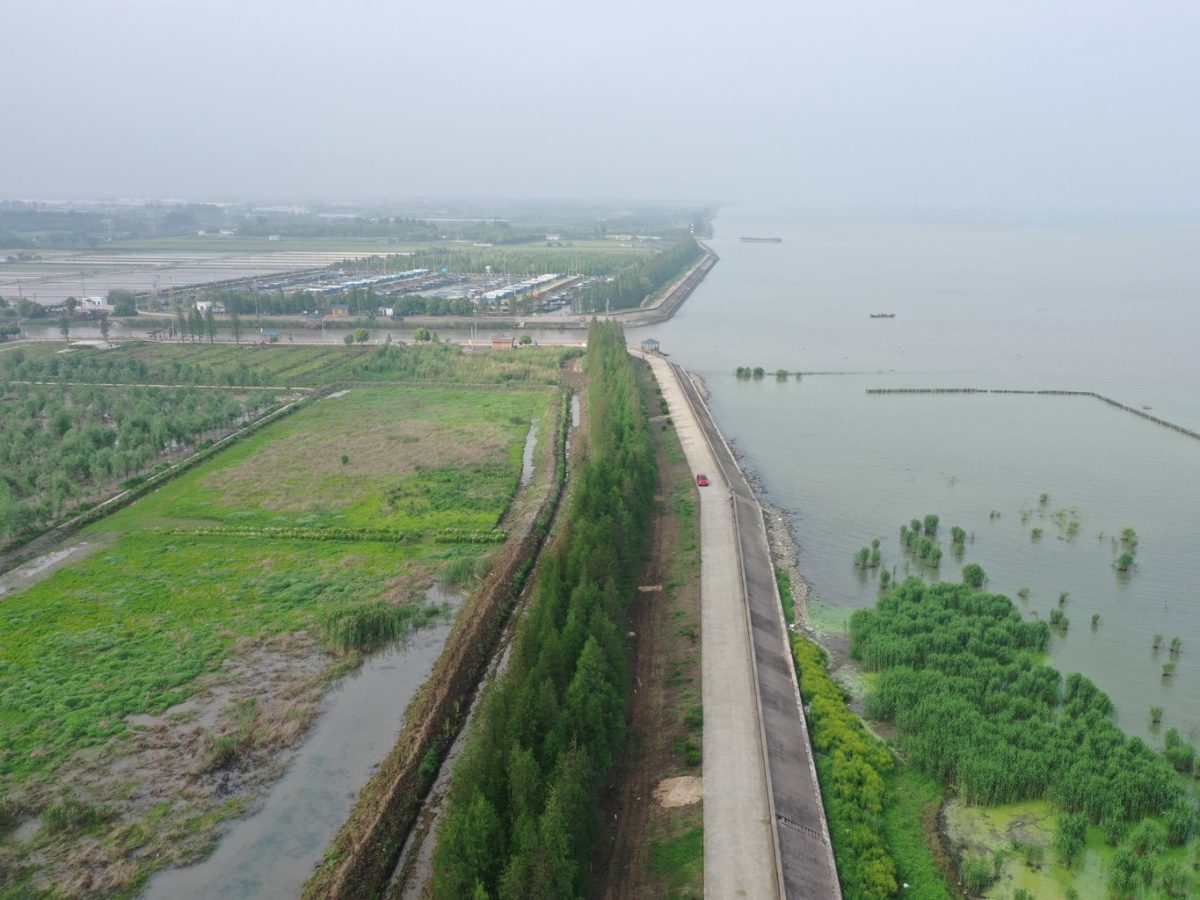
Delta regions throughout the world are densely populated: approximately 50 percent of the world’s urbanized areas are located in deltas (UN-Habitat 2006). The position of deltas in the transition zone between the open sea and the rivers, providing seaport and inland water connections and fresh water, results in favourable locations for trade and settlement. The water and land systems are often completely interwoven through centuries of integrated development.
The urbanized delta areas in the often low-lying deltaic plains also face severe flood risks. Subsidence and climate change (sea level rise and increased river discharges), as well as man-made interventions (such as draining, impermeable surfaces and removing natural discharge canals), further increase the flood risk challenge. To address sea level rise, it is essential to understand the systemic water-land relations and their underlying mechanisms.
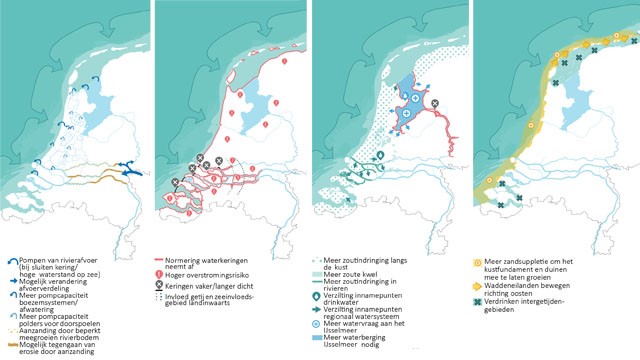
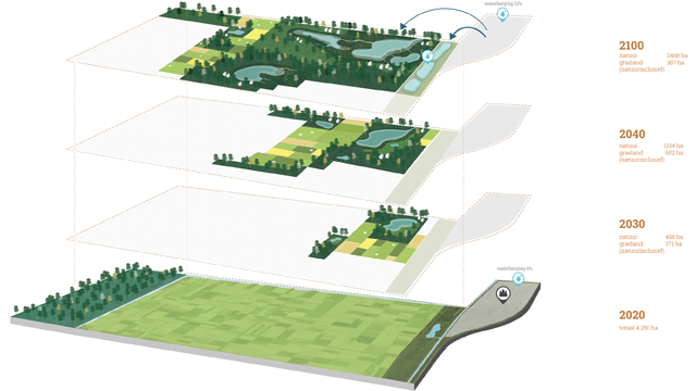
Not only the sea level rise itself, but also the resulting long-term water and flood risk management strategies can and will have a descisive impact on the possible land use in delta areas. In general, possible strategies include a range of options, varying from deltas that remain ecologically valuable open river arms, towards strategies of a closed delta protected by dams or coastal islands (often focused on maintaining fresh water agriculture). In addition to both approaches, it is essential to explore options for adaptation and ‘living with water’.
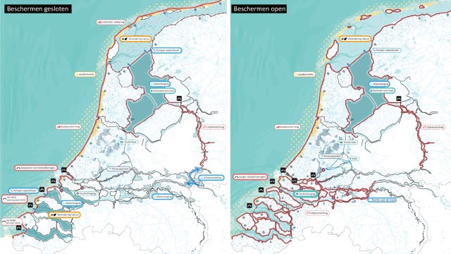
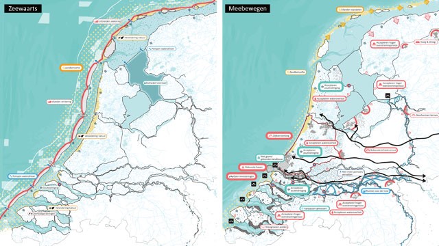
Multidisciplinary research by design approaches are essential to explore the potential opportunities and threats of different long term water management strategies. With extreme sea level rise it will simply not be possible to maintain current landuses in delta areas, which means that strategic choices have to be identified and addressed. Pathways towards a sustainable long term development are essential for designers and engineers to jointly explore and visualise. Rather than focusing on maintaining current values under more and more extreme climate pressures, we should focus on adapting and redefining a more balanced and sustainable 21st century land-water system for urban deltas.
Anne Loes Nillesen is founding director of urban design firm Defacto Architecture and Urbanism, Rotterdam, The Netherlands. Defacto specializes in urban research and design in the domain of water and flood risk management. With her office, Anne Loes has worked on complex, large-scale urban design and flood risk management assignments such as the Dutch Delta Programme and Bangladesh Deltaplan, and several regional and local scale-adaptation projects.
See more from the CITYX Venice Italian Virtual Pavilion here.